Save this image free of charge
in 800 pixels for layout use
(right click, Save as...)
|
|
Ref : V01930
Theme :
Countries-Continents (seen from Space) (255 images)
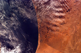
Title : Gaza Strip and the Mediterranean Sea from the Shuttle
Caption :
This image was requested by Buist Academy for the purpose of studying the coast of Israel and the Mediterranean Sea. The electronic still camera, using a 50 mm lens, was used to take this picture which covers an area 102.25 km long and 152.98 km wide. The image is centered at 32.7 degrees north latitude, 34.22 degrees east longitude. Due to shuttle orientation, north is located at approximately eleven o'clock in this image.The Gaza Strip is inhabited by more than 800, 000 Palestinian Arabs and approximately 4,800 Jewish settlers. This image shows the Gaza Strip and the Mediterranean Sea. The border can be seen within the image because of a difference in vegetation patterns, the Egyptian side being less vegetated perhaps due to heavy use of the land for grazing. Like the West Bank, the Gaza Strip was included as part of the British Mandate that lasted from 1917 to 1948. In 1948, an area west of the Jordan River was given to the Jewish people, and the country of Israel was established. Palestinian refugees settled in Gaza and in the West Bank. Since 1948, the Arabs and the Israelis have fought four wars over land. More recently, peace negotiations have occurred between Israeli Prime Minister Benjamin Netanyahu and Palestinian Authority President Yasser Arafat. The project is a result of the effort and collaboration of Johns Hopkins University's Institute for Academic Advancement of Youth, the University of California, San Diego, and NASA's Jet Propulsion Laboratory. The satellite includes a payload of digital still and video cameras that fly on the Space Shuttle. Students operate these cameras from their classrooms, sending instructions to Mission Control Center at UC San Diego via the Internet to photograph specific regions of Earth they wish to study. Image data are sent to the data system during the mission and these images are accessible in the classroom in real time, again using the Internet. At JPL, students on the exploration team research the surrounding area of images and write a summary of its history as shown above.
|
|

